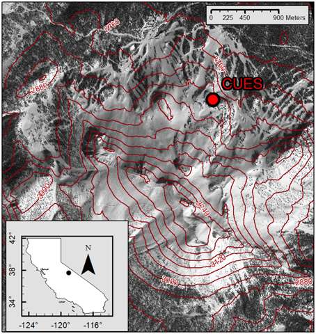
The Jeff Dozier Snow Study Site is a long-term monitoring site of the snowpack mass and energy balance on Mammoth Mountain in the central Sierra Nevada of California.
The site—long managed by the US Army Corps of Engineers Cold Regions Research and Engineering Laboratory (CRREL) and the University of California, Santa Barbara (UCSB)—was known until recently as the CRREL and UCSB Energy Site (CUES) and has been renamed in honor of the late Dr. Jeff Dozier.
Coordinates: 37.6431°N, 119.0291°W
Elevation: 2936 m (9633 ft)


Site Layout & Characteristics
- The Dozier snow site is located midway up Mammoth Mountain—a silica dome cluster with a base elevation of 2424 m (7593 ft) and a summit of 3369 m (11053 m) that is home to one of the busiest ski resorts in North America
- The site is a short walk from McCoy Station and the Panorama Gondola, which provides easy and reliable access to the site year-round
- Manual snowfall and meteorological measurements near the Dozier site began in 1968 as part of the USDA Forest Service Snow Ranger Program
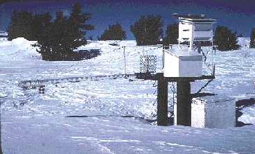
- Scientific snow observations began in the 1970s at a small instrumented platform located approximately 200 m away from the current platform
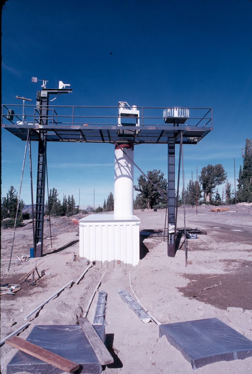
- At the request of Mammoth Mountain Ski Area, the site was moved to the its current location in 1987
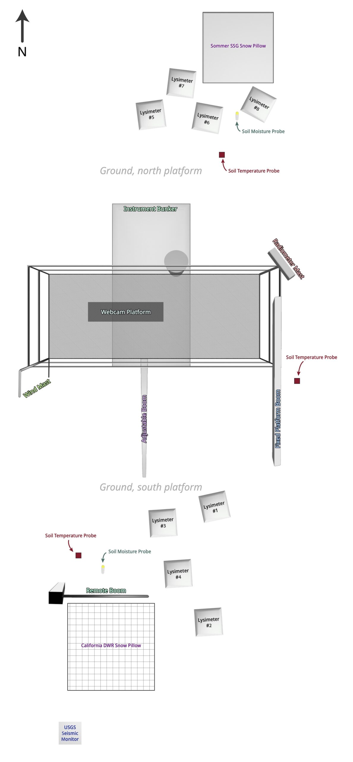
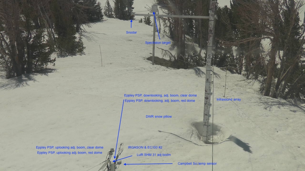
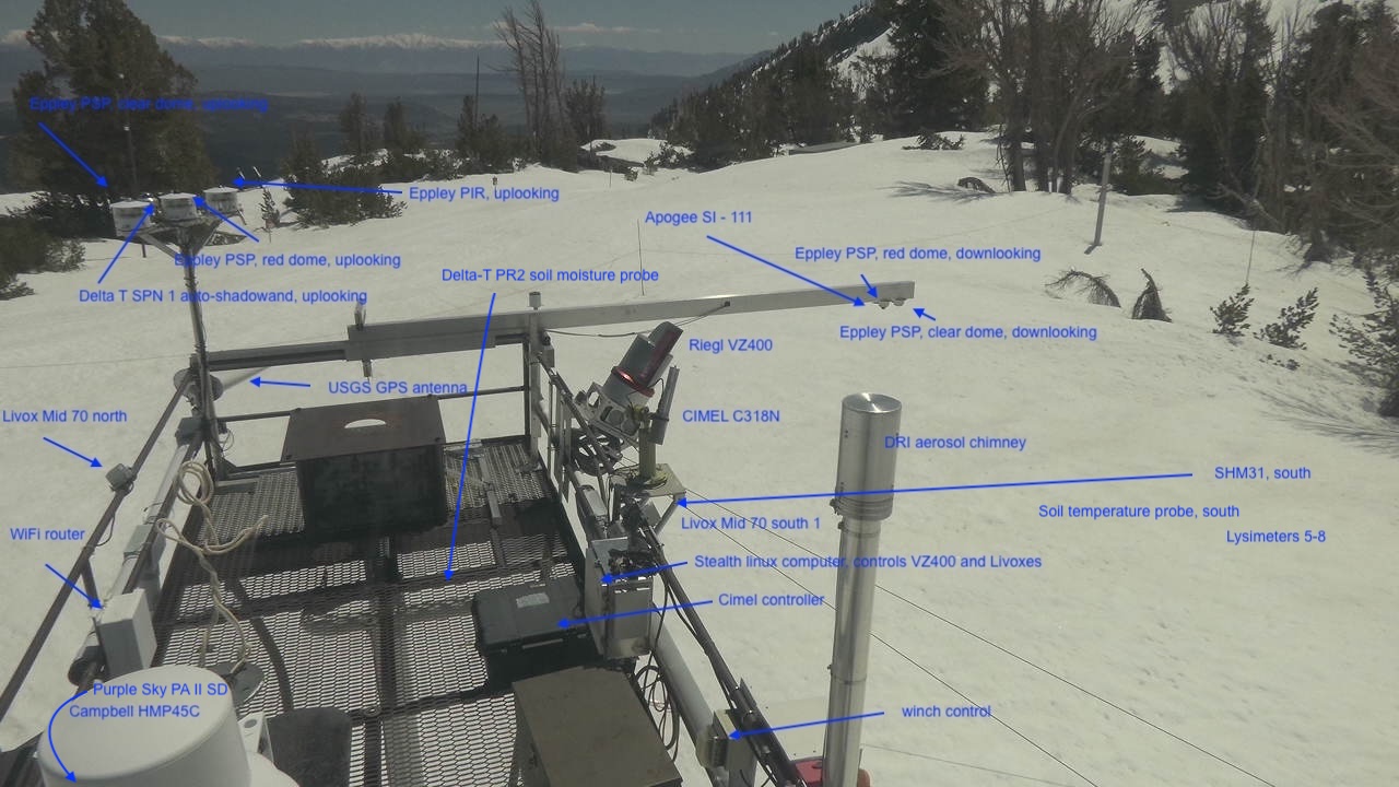
Top-Down View of the Dozier Site – Platform & Ground Instrumentation
Current Instrumentation
| Instrument | Primary Measurement | Location | Instrument Height | Height Reference | Start Date (Instrument) |
Start Date (Equivalent Measurement) |
Website Data Access |
Level1 – Database MeasurementGroup |
Status (Long-term or Guest Instrument) |
|---|---|---|---|---|---|---|---|---|---|
| Apogee SI-111 thermal radiometer | snow surface (skin) temperature | Fixed platform boom | 6.8 m | above bare ground | 2016-11-03 | 2016-11-03 | Yes | Temperatures | Long-term |
| California Dept. of Water Resources snow pillow | snow water equivalent (SWE) | Ground, south side | 0.0 m | above bare ground | 2012-09-25 | 2012-09-25 | Yes | Precipitation | Long-term |
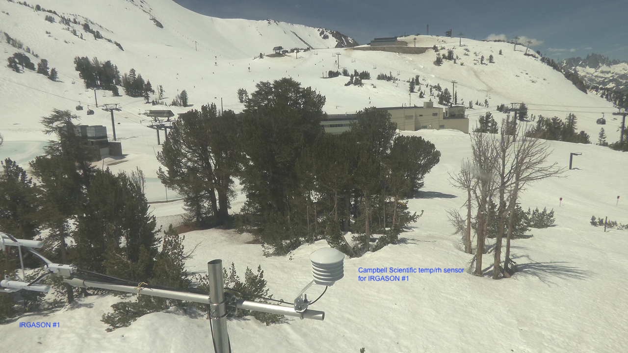
| Campbell Scientific IRGASON & EC100 | surface fluxes | Platform, wind mast | 8.2 m | above bare ground | 2023-09-22 | 2010-08-25 | Yes | — | Long-term |
| Campbell Scientific IRGASON & EC100 | surface fluxes | Adjustable boom | 1.0 m | above bare ground or snow surface (approx.) | 2023-09-22 | 2021-10-01 | Yes | — | Long-term |
| CIMEL CE-318M sun photometer | NASA AERONET aerosol optical depth | Platform, south railing | 6.8 m | above bare ground | 2022-03-17 | 2022-03-17 | Yes | — | Long-term |
| Delta-T PR2/6 soil moisture probe (north) | soil moisture | Ground, north side | 0.1, 0.2, 0.3, 0.4, 0.6, 1.0 m | below ground surface | 2007-08-17 | 2007-08-17 | Yes | Soil | Long-term |
| Delta-T PR2/6 soil moisture probe (south) | soil moisture | Ground, south side | 0.1, 0.2, 0.3, 0.4, 0.6, 1.0 m | below ground surface | 2007-08-17 | 2007-08-17 | Yes | Soil | Long-term |
| Delta-T SPN1 sunshine pyranometer | total & diffuse downwelling solar radiation | Platform, radiometer mast | 7.5 m | above bare ground | 2010-02-04 | 1999-10-01 | Yes | Radiation | Long-term |
| Delta-T ST1-05 soil temperature probe (center) | soil temperature | Ground, east side | 0, 0.1, 0.2, 0.3, 0.4, 0.5, 0.6, 0.7, 0.8, 0.9 m | below ground surface | 2007-08-17 | 2007-08-17 | Yes | Temperatures | Long-term |
| Delta-T ST1-05 soil temperature probe (north) | soil temperature | Ground, north side | 0, 0.1, 0.2, 0.3, 0.4, 0.5, 0.6, 0.7, 0.8, 0.9 m | below ground surface | 2012-09-08 | 2012-09-08 | Yes | Temperatures | Long-term |
| Delta-T ST1-05 soil temperature probe (south) | soil temperature | Ground, south side | 0, 0.1, 0.2, 0.3, 0.4, 0.5, 0.6, 0.7, 0.8, 0.9 m | below ground surface | 2012-09-08 | 2012-09-08 | Yes | Temperatures | Long-term |
| DRI SANTRI2 saltation instrument A | dust & snow saltation flux | Adjustable boom | 0.4 m | above bare ground or snow surface (approx.) | 2025-09-09 | 2025-09-09 | Yes | — | Guest (George Nikolich, DRI) |
| DRI SANTRI2 saltation instrument B | dust & snow saltation flux | Adjustable boom | 0.4 m | above bare ground or snow surface (approx.) | 2025-09-09 | 2025-09-09 | Yes | — | Guest (George Nikolich, DRI) |
| DRI SANTRI2 saltation instrument C | dust & snow saltation flux | Platform, west railing | 6.8 m | above bare ground | 2025-09-09 | 2025-09-09 | Yes | — | Guest (George Nikolich, DRI) |
| Eppley PIR (longwave, uplooking) | downwelling longwave infrared radiation | Platform, radiometer mast | 7.5 m | above bare ground | 1992-04-13 | 1992-04-13 | Yes | Radiation | Long-term |
| Eppley PSP (clear, downlooking) | reflected broadband solar radiation | Fixed platform boom | 6.8 m | above bare ground | 2006-08-09 | 1997-04-19 | Yes | Radiation | Long-term |
| Eppley PSP (clear, downlooking) | reflected broadband solar radiation | Adjustable boom | 0.8 m | above bare ground or snow surface (approx.) | 2018-09-17 | 2015-09-25 | Yes | Radiation | Long-term |
| Eppley PSP (clear, uplooking) | downwelling broadband solar radiation | Platform, radiometer mast | 7.5 m | above bare ground | 2015-09-21 | 1992-04-13 | Yes | Radiation | Long-term |
| Eppley PSP (clear, uplooking) | downwelling broadband solar radiation | Adjustable boom | 1.3 m | above bare ground or snow surface (approx) | 2020-10-17 | 2020-10-17 | Yes | Radiation | Long-term |
| Eppley PSP (red, downlooking) | reflected near-infrared radiation | Fixed platform boom | 6.8 m | above bare ground | 2006-08-09 | 1997-04-19 | Yes | Radiation | Long-term |
| Eppley PSP (red, downlooking) | reflected near-infrared radiation | Adjustable boom | 0.8 m | above bare ground or snow surface (approx.) | 2018-09-17 | 2015-09-25 | Yes | Radiation | Long-term |
| Eppley PSP (red, uplooking) | downwelling near-infrared radiation | Platform, radiometer mast | 7.5 m | above bare ground | 1992-04-13 | 1992-04-13 | Yes | Radiation | Long-term |
| Eppley PSP (red, uplooking) | downwelling near-infrared radiation | Adjustable boom | 1.3 m | above bare ground or snow surface (approx.) | 2020-10-17 | 2020-10-17 | Yes | Radiation | Long-term |
| Livox Mid-70 scanning lidar #1 | snow depth & heterogeneity | Platform, north railing | 6.4 m | above bare ground | 2021-10-07 | 2021-10-07 | Yes | — | Long-term |
| Livox Mid-70 scanning lidar #2 | snow depth & heterogeneity | Platform, south(east) railing | 6.6 m | above bare ground | 2021-10-07 | 2021-10-07 | Yes | — | Long-term |
| Livox Mid-70 scanning lidar #3 | snow depth & heterogeneity | Platform, south(west) railing | 6.6 m | above bare ground | 2021-10-07 | 2021-10-07 | Yes | — | Long-term |
| Lufft SHM31 laser snow depth sensor #1 (south) | snow depth | Platform, south railing | 6.4 m | above bare ground | 2019-08-31 | 2019-08-31 | Yes | Precipitation | Long-term |
| Lufft SHM31 laser snow depth sensor #2 (north) | snow depth | Platform, webcam stand | 9.0 m | above bare ground | 2020-10-11 | 2020-10-11 | Yes | Precipitation | Long-term |
| Lufft SHM31 laser snow depth sensor #3 (boom) | height above snow surface | Adjustable boom | 1.0 m | above bare ground or snow surface (approx.) | 2023-09-17 | 2016-11-28 | Yes | Precipitation | Long-term |
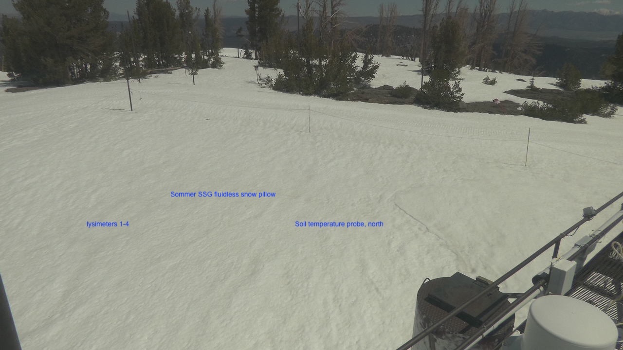
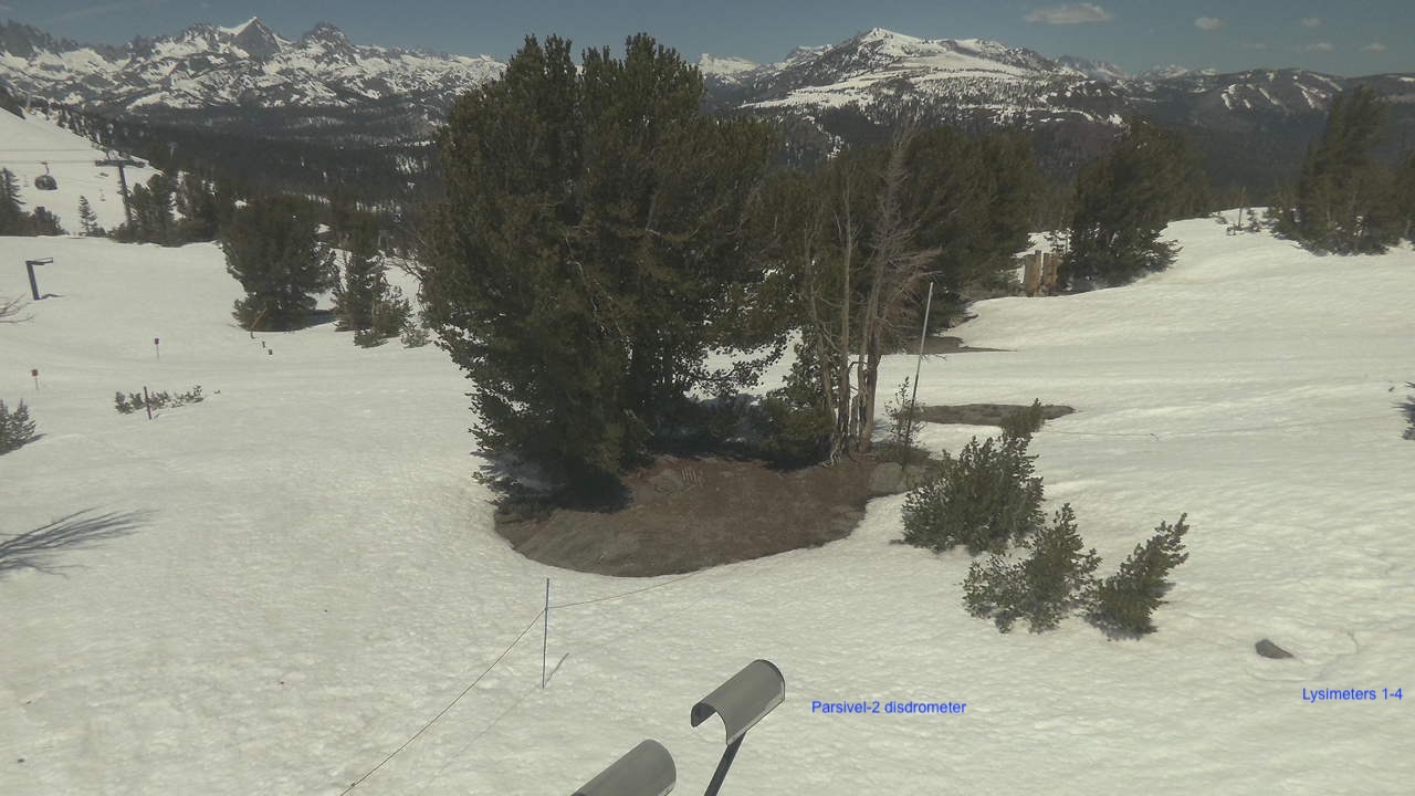
| Lysimeters & tipping buckets #1–4 (south) | snow meltwater volume | Ground, south side | 0.0 m | above bare ground | 2024-09-15 | 1992-04-13 | Yes | Lysimeters | Long-term |
| Lysimeters & tipping buckets #5–8 (north) | snow meltwater volume | Ground, north side | 0.0 m | above bare ground | 2024-09-15 | 1992-04-13 | Yes | Lysimeters | Long-term |
| Met One 092 barometer | station pressure | Bunker | 1.0 m | above bare ground | 2007-08-17 | 2007-08-17 | Yes | Temperatures | Long-term |
| NASA JPL Ku-band radar | snowpack properties | Platform, north railing | 6.9 m | above bare ground | 2024-10-10 | 2024-10-10 | No | — | Guest (HP Marshall, BSU) |
| OTT HydroMet Parsivel2 laser disdrometer | precipitation | Platform, northwest corner | 7.6 m | above bare ground | 2020-10-14 | 2020-10-14 | Yes | Parsivel | Long-term |
| Panasonic webcam | current conditions | Platform, webcam stand | 9.0 m | above bare ground | 2023-09-25 | 1999-09-19 | Yes | — | Long-term |
| PurpleAir Classic Plus air quality monitor | air quality | Platform, webcam stand | 8.2 m | above bare ground | 2021-08-06 | 2021-08-06 | Yes | Air Quality | Long-term |
| Riegl VZ-400i scanning lidar | snow depth & heterogeneity | Platform, south railing | 6.7 m | above bare ground | 2020-10-21 | 2020-10-21 | Yes | — | Long-term |
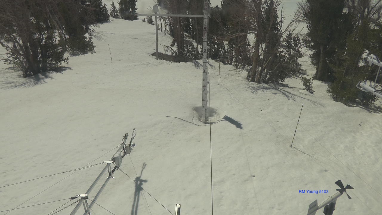
| RM Young 05130 propeller vane anemometer | wind speed & direction | Platform, wind mast | 7.2 m | above bare ground | 2022-08-23 | 1997-01-31 | Yes | Winds | Long-term |
| SensorLogic SNOdar laser snow depth sensor | snow depth | Remote boom | 6.4 m | above bare ground | 2024-09-12 | 1999-10-01 | Yes | Precipitation | Long-term |
| Sommer SSG-2 fluidless snow pillow | snow water equivalent (SWE) | Ground, north side | 0.0 m | above bare ground | 2024-09-12 | 2024-09-12 | Yes | Precipitation | Long-term |
| Telaire T8200-10P Ventostat sensor | indoor air temperature & CO2 concentration | Bunker | 1.0 m | above bare ground | 2007-08-17 | 2007-08-17 | Yes | Temperatures | Long-term |
| Vaisala HMP45C temperature/humidity probe | air temperature & humidity | Platform, webcam stand | 8.3 m | above bare ground | — | 1992-04-13 | Yes | Temperatures | Long-term |
Last updated 12/18/2025
References
Bair, E. H., R. E. Davis, and J. Dozier (2018), Hourly mass and snow energy balance measurements from Mammoth Mountain, CA USA, 2011–2017, Earth System Science Data, 10, 549-563, doi: 10.5194/essd-10-549-2018. [pdf]
Bair, E.H., Dozier, J., Colee, M. and Claffey, K. (2015) CUES – A Study Site for Measuring Snowpack Energy Balance in the Sierra Nevada. Frontiers in Geoscience 3, doi: 10.3389/feart.2015.00058. [pdf]