Archived Data

Raw data files from 1992 – present

  • Majority of files are organized into folders by year and are in .dat (ASCII) format → output from Campbell Scientific dataloggers
  • These folders also include high-frequency observations from the RM Young sonic anemometer and the two IRGASON systems that are not included in the Level 1 – Database
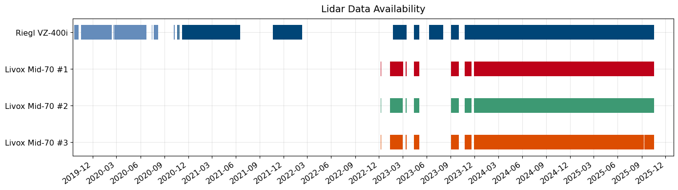
  • Point clouds from the Riegl and Livox scanning lidars are available in the /lidar folder
Lidar data available for download through 10/17/2025. The light blue period indicates when the Riegl VZ-400i
was deployed at Sesame, and the dark blue period indicates when the lidar was located at the Dozier Site.
Last updated: 12/18/2025

MySQL database interface for querying data from 1992 – present

  • Database contains point-based observations recorded at intervals ≥ 1 minute
  • Observations can be queried by MeasurementGroup or Measurement
  • Data can be obtained at raw recording frequency (i.e., same as in Level 0 – Raw files) or aggregated to hourly or daily averages or sums
  • Does not include high-frequency observations from the RM Young sonic anemometer and the two IRGASON systems
  • Does not include spatially distributed measurements, such as point clouds from the Riegl and Livox scanning lidars

Quality-controlled and post-processed observations for various periods

Dozier Site:

  • Daily Snow Depth:  03/20/2001 – 04/28/2015  [file] [readme]
  • Daily Winds:  11/13/2002 – 05/12/2015  [file] [readme]
  • Monthly High and Low Temperatures:  04/1993 – 09/2014  [file] [readme]
  • QCed Data – Various Measurements:  01/01/2015 – 06/30/2025  [folder] [readme]

Sesame:

  • Temperature, Humidity, Snow Depth, and SWE:  10/01/2010 – 09/10/2017  [file]
  • Manual Precipitation, Snow Depth, SWE, and Notes:  10/05/2010 – 06/12/2017  [file]

Mammoth Pass:

  • Precipitation, Snow Depth, and SWE:  10/01/2010 – 09/09/2017  [file]